logo
Good price  online

products details

Home > Products >
GNSS RTK Receiver
>
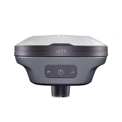
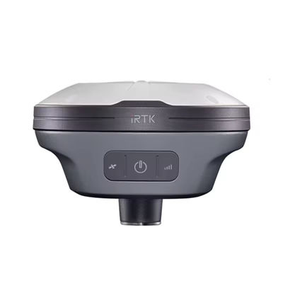
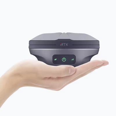
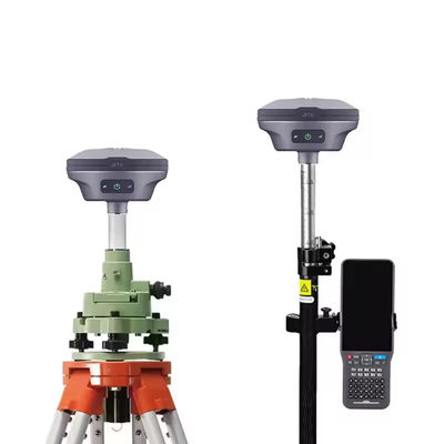
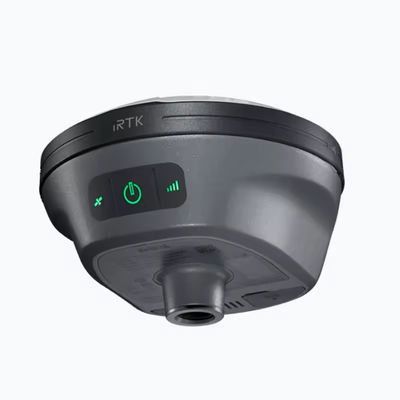
GNSS RTK Hi -Target IRTK10 Upgrade For Land Surveying Instruments Survey IMU GPS

GNSS RTK Hi -Target IRTK10 Upgrade For Land Surveying Instruments Survey IMU GPS

Brand Name: Hi-target
Model Number: iRTK10
MOQ: 1 piece
Price: $2,800.00
Payment Terms: L/C, T/T
Detail Information
Place of Origin:
China
Product Name:
RTK Receiver Hi-target IRTK10
Material:
Magnesium Alloy
Application:
Land Surveying
Channels:
660
GPS:
L1,L2,L5
GLONASS:
L1,L2
BDS:
B1,B2,B3
I/0 Port:
USB Type-C Port, SMA Port
Supply Ability:
1 ~ 30 day
Highlight:

imu rtk gnss

,

imu gnss rtk receiver

,

gps rtk gnss

Product Description

GNSS RTK Hi -target IRTK10 Upgrade for Land Surveying Instruments Survey IMU GPS 

Overview
 
Products Description
configuration
Channel: 660
BDS:B1,B2,B3
GPS:L1,L2,L5
GLONASS:L1,L2
GALILIEO:E1,E5a,E5b
SBAS:Support
QZSS:Support
Output format
ASCII:NMEA-0183,Binary code
Positioning output frequency
1Hz~20Hz
Static data format
GNS,Rinex dual-format static data
Difference scheme
CMR,RTCM2.X,RTCM3.0,RTCM3.2
Network mode
VRS,FKP,MAC; Supports the NTRIP protocol
System configuration
Operating system
Linux Operating system
Start-up time
3 seconds
Data storage
Built-in 8GB ROM, support static data automatic cycle storage
Accuracy and reliability
RTK positioning accuracy
Plane: ±(8+1×10⁻⁶D)mm(D is the distance between measured points)
Height: ±(15+1×10⁻⁶D)mm(D is the distance between measured points)
Static positioning accuracy
Plane: ±(2.5+0.5×10⁻⁶D)mm(D is the distance between measured points)
Height: ±(5+0.5×10⁻⁶D)mm(D is the distance between measured points)
DGPS positioning accuracy
Plane accuracy: ±0.25m+1ppm; Elevation accuracy: ±0.50m+1ppm
SBAS positioning accuracy
0.5m
Initialization time
<10 seconds
Initialization reliability
>99.99%
Communication unit
I/0 port
USB Type-C port, SMA port
Built-in network
Built-in eSIM card, including 3 years of Internet access fee, you can start the Internet
WiFi communication
802.11a /b/g/n access point and client mode to provide WiFi hotspot services
Bluetooth communication
Bluetooth@ 4.2/2.1+EDR,2.4GHz
Built-in station
Built-in transceiver integrated radio:
Power: 0.5W/1W/2W adjustable
Frequency band: 410MHz to 470MHz
Protocol: HI - TARGET, TRIMTALK450S TRIMMARKIII, TRANSEOT, CHC
Number of channels: 116(16 of which are configurable)
 
 
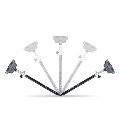
GNSS RTK Hi -Target IRTK10  Upgrade For Land Surveying Instruments Survey IMU GPS 0
GNSS RTK Hi -Target IRTK10  Upgrade For Land Surveying Instruments Survey IMU GPS 1
GNSS RTK Hi -Target IRTK10  Upgrade For Land Surveying Instruments Survey IMU GPS 2
GNSS RTK Hi -Target IRTK10  Upgrade For Land Surveying Instruments Survey IMU GPS 3
GNSS RTK Hi -Target IRTK10  Upgrade For Land Surveying Instruments Survey IMU GPS 4
GNSS RTK Hi -Target IRTK10  Upgrade For Land Surveying Instruments Survey IMU GPS 5
GNSS RTK Hi -Target IRTK10  Upgrade For Land Surveying Instruments Survey IMU GPS 6
GEODETSKOJ ŠKOLI SPLIT isporučujemo STONEX totalne stanice, teodolite i GNSS prijemnike
Geodetske škole imaju ključnu ulogu u pružanju učenicima potrebnog znanja i vještina u području geodezije.Integracija najnovijih
geodetskih instrumenata u takve obrazovne ustanové može značajno poboljšati iskustvo učenika i bolje ih pripremiti za primjenu u
stvarnom svijetu.Najnoviji geodetski instrumenti nude napredne značajke i mogućnosti koje mogu pružiti studentima intenzivnije
iskustvo učenja.Korištenjem ovih instrumenata, studenti mogu steći praktično iskustvo u prikupljanju podataka, analizi itumačenju, što su ključne vještine u području geodezije.
U suradnji sa STONEX S.r.l. Italija, geodetskoj školi u Splitu isporučili smo najnovije totalne stanice, teodolite i GNSS prijemnike.
GNSS RTK Hi -Target IRTK10  Upgrade For Land Surveying Instruments Survey IMU GPS 7
GNSS RTK Hi -Target IRTK10  Upgrade For Land Surveying Instruments Survey IMU GPS 8
 
 
Certifications
GNSS RTK Hi -Target IRTK10  Upgrade For Land Surveying Instruments Survey IMU GPS 9
GNSS RTK Hi -Target IRTK10  Upgrade For Land Surveying Instruments Survey IMU GPS 10
 
Company Profile
GNSS RTK Hi -Target IRTK10  Upgrade For Land Surveying Instruments Survey IMU GPS 11
 

FAQ


1. who are we?
We are based in sichuan, China, start from 2016,sell to Africa(30.00%),Southeast Asia(16.00%),Mid East(11.00%),Eastern
Asia(10.00%),South America(10.00%),Central America(5.00%),South Asia(5.00%),Southern Europe(5.00%),North America(4.00%),Eastern
Europe(4.00%). There are total about 11-20 people in our office.

2. how can we guarantee quality?
Always a pre-production sample before mass production;
Always final Inspection before shipment;

3.what can you buy from us?
GNSS RTK,Total station,Level,Survey accessory,laser rangefinder

4. why should you buy from us not from other suppliers?
1.More than 20 years of experience in the trade field. 2.All products will have been strictly quality checked in factory before
sending out and all products have one year warranty.

5. what services can we provide?
Accepted Delivery Terms: FOB,CFR,CIF,EXW,FAS,CIP,FCA,CPT,DEQ,DDP,DDU,Express Delivery,DAF,DES;
Accepted Payment Currency:USD,EUR,JPY,CAD,AUD,HKD,GBP,CNY,CHF;
Accepted Payment Type: T/T,L/C,D/P D/A,MoneyGram,Credit Card,PayPal,Western Union,Cash,Escrow;
Language Spoken:English,Chinese,Spanish,Japanese,Portuguese,German,Arabic,French,Russian,Korean,Hindi,Italian


Our Service
GNSS RTK Hi -Target IRTK10  Upgrade For Land Surveying Instruments Survey IMU GPS 12
 
Packing & Delivery
GNSS RTK Hi -Target IRTK10  Upgrade For Land Surveying Instruments Survey IMU GPS 13
Good price  online

Products Details

Home > Products >
GNSS RTK Receiver
>
GNSS RTK Hi -Target IRTK10 Upgrade For Land Surveying Instruments Survey IMU GPS

GNSS RTK Hi -Target IRTK10 Upgrade For Land Surveying Instruments Survey IMU GPS

Brand Name: Hi-target
Model Number: iRTK10
MOQ: 1 piece
Price: $2,800.00
Payment Terms: L/C, T/T
Detail Information
Place of Origin:
China
Brand Name:
Hi-target
Model Number:
iRTK10
Product Name:
RTK Receiver Hi-target IRTK10
Material:
Magnesium Alloy
Application:
Land Surveying
Channels:
660
GPS:
L1,L2,L5
GLONASS:
L1,L2
BDS:
B1,B2,B3
I/0 Port:
USB Type-C Port, SMA Port
Minimum Order Quantity:
1 piece
Price:
$2,800.00
Delivery Time:
30 work day
Payment Terms:
L/C, T/T
Supply Ability:
1 ~ 30 day
Highlight:

imu rtk gnss

,

imu gnss rtk receiver

,

gps rtk gnss

Product Description

GNSS RTK Hi -target IRTK10 Upgrade for Land Surveying Instruments Survey IMU GPS 

Overview
 
Products Description
configuration
Channel: 660
BDS:B1,B2,B3
GPS:L1,L2,L5
GLONASS:L1,L2
GALILIEO:E1,E5a,E5b
SBAS:Support
QZSS:Support
Output format
ASCII:NMEA-0183,Binary code
Positioning output frequency
1Hz~20Hz
Static data format
GNS,Rinex dual-format static data
Difference scheme
CMR,RTCM2.X,RTCM3.0,RTCM3.2
Network mode
VRS,FKP,MAC; Supports the NTRIP protocol
System configuration
Operating system
Linux Operating system
Start-up time
3 seconds
Data storage
Built-in 8GB ROM, support static data automatic cycle storage
Accuracy and reliability
RTK positioning accuracy
Plane: ±(8+1×10⁻⁶D)mm(D is the distance between measured points)
Height: ±(15+1×10⁻⁶D)mm(D is the distance between measured points)
Static positioning accuracy
Plane: ±(2.5+0.5×10⁻⁶D)mm(D is the distance between measured points)
Height: ±(5+0.5×10⁻⁶D)mm(D is the distance between measured points)
DGPS positioning accuracy
Plane accuracy: ±0.25m+1ppm; Elevation accuracy: ±0.50m+1ppm
SBAS positioning accuracy
0.5m
Initialization time
<10 seconds
Initialization reliability
>99.99%
Communication unit
I/0 port
USB Type-C port, SMA port
Built-in network
Built-in eSIM card, including 3 years of Internet access fee, you can start the Internet
WiFi communication
802.11a /b/g/n access point and client mode to provide WiFi hotspot services
Bluetooth communication
Bluetooth@ 4.2/2.1+EDR,2.4GHz
Built-in station
Built-in transceiver integrated radio:
Power: 0.5W/1W/2W adjustable
Frequency band: 410MHz to 470MHz
Protocol: HI - TARGET, TRIMTALK450S TRIMMARKIII, TRANSEOT, CHC
Number of channels: 116(16 of which are configurable)
 
 
GNSS RTK Hi -Target IRTK10  Upgrade For Land Surveying Instruments Survey IMU GPS 0
GNSS RTK Hi -Target IRTK10  Upgrade For Land Surveying Instruments Survey IMU GPS 1
GNSS RTK Hi -Target IRTK10  Upgrade For Land Surveying Instruments Survey IMU GPS 2
GNSS RTK Hi -Target IRTK10  Upgrade For Land Surveying Instruments Survey IMU GPS 3
GNSS RTK Hi -Target IRTK10  Upgrade For Land Surveying Instruments Survey IMU GPS 4
GNSS RTK Hi -Target IRTK10  Upgrade For Land Surveying Instruments Survey IMU GPS 5
GNSS RTK Hi -Target IRTK10  Upgrade For Land Surveying Instruments Survey IMU GPS 6
GEODETSKOJ ŠKOLI SPLIT isporučujemo STONEX totalne stanice, teodolite i GNSS prijemnike
Geodetske škole imaju ključnu ulogu u pružanju učenicima potrebnog znanja i vještina u području geodezije.Integracija najnovijih
geodetskih instrumenata u takve obrazovne ustanové može značajno poboljšati iskustvo učenika i bolje ih pripremiti za primjenu u
stvarnom svijetu.Najnoviji geodetski instrumenti nude napredne značajke i mogućnosti koje mogu pružiti studentima intenzivnije
iskustvo učenja.Korištenjem ovih instrumenata, studenti mogu steći praktično iskustvo u prikupljanju podataka, analizi itumačenju, što su ključne vještine u području geodezije.
U suradnji sa STONEX S.r.l. Italija, geodetskoj školi u Splitu isporučili smo najnovije totalne stanice, teodolite i GNSS prijemnike.
GNSS RTK Hi -Target IRTK10  Upgrade For Land Surveying Instruments Survey IMU GPS 7
GNSS RTK Hi -Target IRTK10  Upgrade For Land Surveying Instruments Survey IMU GPS 8
 
 
Certifications
GNSS RTK Hi -Target IRTK10  Upgrade For Land Surveying Instruments Survey IMU GPS 9
GNSS RTK Hi -Target IRTK10  Upgrade For Land Surveying Instruments Survey IMU GPS 10
 
Company Profile
GNSS RTK Hi -Target IRTK10  Upgrade For Land Surveying Instruments Survey IMU GPS 11
 

FAQ


1. who are we?
We are based in sichuan, China, start from 2016,sell to Africa(30.00%),Southeast Asia(16.00%),Mid East(11.00%),Eastern
Asia(10.00%),South America(10.00%),Central America(5.00%),South Asia(5.00%),Southern Europe(5.00%),North America(4.00%),Eastern
Europe(4.00%). There are total about 11-20 people in our office.

2. how can we guarantee quality?
Always a pre-production sample before mass production;
Always final Inspection before shipment;

3.what can you buy from us?
GNSS RTK,Total station,Level,Survey accessory,laser rangefinder

4. why should you buy from us not from other suppliers?
1.More than 20 years of experience in the trade field. 2.All products will have been strictly quality checked in factory before
sending out and all products have one year warranty.

5. what services can we provide?
Accepted Delivery Terms: FOB,CFR,CIF,EXW,FAS,CIP,FCA,CPT,DEQ,DDP,DDU,Express Delivery,DAF,DES;
Accepted Payment Currency:USD,EUR,JPY,CAD,AUD,HKD,GBP,CNY,CHF;
Accepted Payment Type: T/T,L/C,D/P D/A,MoneyGram,Credit Card,PayPal,Western Union,Cash,Escrow;
Language Spoken:English,Chinese,Spanish,Japanese,Portuguese,German,Arabic,French,Russian,Korean,Hindi,Italian


Our Service
GNSS RTK Hi -Target IRTK10  Upgrade For Land Surveying Instruments Survey IMU GPS 12
 
Packing & Delivery
GNSS RTK Hi -Target IRTK10  Upgrade For Land Surveying Instruments Survey IMU GPS 13